With the festivities in full swing and when Storm Barbara moves on many people will take to the nation’s beaches and cliffs to take in the fresh air and clear the cobwebs. This can be a busy time of the year for Irish Coast Guard personnel from crews in the air to crews on the coast and not forgetting our control room staff taking in the 112/ 999 emergency calls.
The information communicated in that emergency call is critical; we need to know what has happened and where; the “where” can be tricky. People with the best of intentions can give the location they started off from or are travelling to which could be 10km away from where the actual emergency is. Unlike travelling to a street address access to a cliff or beach tends to be a challenge. Arriving at the right location can save time for our Coast Guard Rescue Teams, time that could save someone’s life.
To do this we’d like you to help us. Tell us your numbers.. not your favourite lottery ones but your GPS co-ordinates, this will give us your location and we can plan the best and quickest way to get to you. . From Smart Phones these numbers can be easily attained from apps of which they are lots of. Let’s just look at the standard ones that comes with both iPhone and Android.
You’ll see two sets of numbers that give you your longitude and latitude, these are the ones we need. The default setting for Google maps gives you a different gps format (degrees and decimal minutes) than the iPhone Compass (degrees, minutes and seconds). Let’s leave it simple, tell us which phone app you’re using and we’ll work it out. Phone signal can drop in some coastal areas so be prepared for plan b, to get to the nearest house to phone for help.
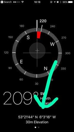
For iPhone users its quick. Open the Compass app and you have your GPS co-ordinates at the bottom (53° 21’ 44”, 6° 3’ 16”).
The information communicated in that emergency call is critical; we need to know what has happened and where; the “where” can be tricky. People with the best of intentions can give the location they started off from or are travelling to which could be 10km away from where the actual emergency is. Unlike travelling to a street address access to a cliff or beach tends to be a challenge. Arriving at the right location can save time for our Coast Guard Rescue Teams, time that could save someone’s life.
To do this we’d like you to help us. Tell us your numbers.. not your favourite lottery ones but your GPS co-ordinates, this will give us your location and we can plan the best and quickest way to get to you. . From Smart Phones these numbers can be easily attained from apps of which they are lots of. Let’s just look at the standard ones that comes with both iPhone and Android.
You’ll see two sets of numbers that give you your longitude and latitude, these are the ones we need. The default setting for Google maps gives you a different gps format (degrees and decimal minutes) than the iPhone Compass (degrees, minutes and seconds). Let’s leave it simple, tell us which phone app you’re using and we’ll work it out. Phone signal can drop in some coastal areas so be prepared for plan b, to get to the nearest house to phone for help.
For iPhone users its quick. Open the Compass app and you have your GPS co-ordinates at the bottom (53° 21’ 44”, 6° 3’ 16”).
For Android users the quickest way is to simply open google maps drop the red pin beside your location which should be showing on the map and the GPS co-ordinates eg (53.353353, -6.163957) will appear in a dialogue box.
Video: https://youtu.be/KiTkdj5_hDw
On behalf of everyone in the Irish Coast Guard station in Howth we wish you all a very happy and safe Christmas.
Video: https://youtu.be/KiTkdj5_hDw
On behalf of everyone in the Irish Coast Guard station in Howth we wish you all a very happy and safe Christmas.
 RSS Feed
